We’re very excited to formally release SatExplorer - VIRIDIEN (formerly CGG) Satellite Mapping’s web-based platform to deliver, visualize, and analyze data from VIRIDIEN Satellite Mapping.
It’s nothing new that Earth Observation datasets are becoming exponentially larger. It's also not new that gaining valuable intelligence and information from these datasets is becoming a bigger challenge. Compounding these challenges, the beneficiaries and end-users are often not Earth Observation scientists or data scientists. In almost all cases, end-users want an intuitive, accurate, and secure solution to quickly gain insights from these datasets. SatExplorer has been developed to address these challenges and desires of our customers. SatExplorer is the vehicle to help our carefully and expertly handled data benefit our customers. The vehicle is important, but clients want this with the reassurance that the data and tools being served to them via SatExplorer are of the highest industry standards.
The Satellite Mapping team at VIRIDIEN was formed over 50 years ago and has been leading the commercial use of satellite remote sensing data in a variety of industries ever since. Our highly experienced Earth Observation data specialists have worked closely with clients in those industries and taken on their feedback to ensure SatExplorer doesn’t just address their objectives and pain points, but fulfils them.
To cope with the ever-increasing size of EO datasets and the computer processing required to make sense of it all, VIRIDIEN is uniquely placed amongst our competitors. We have access to the supercomputing, AI-data-crunching powerhouse of VIRIDIEN's High Powered Computing (HPC) with over 500 petaFLOPS of computing power – that’s over 500 quadrillion floating-point operations per second. Or in an Earth Observation sense, it allows us to make and iterate through stacks of 1000's of interferograms in seconds not days, or process the entire archive of ASTER multispectral data to produce the barest Earth mosaic possible: VIRIDIEN’s BareEarth+. This frees up our Remote Sensing experts' time to build reports and deliverables that are even more catered to specific end-user requirements derived from datasets only VIRIDIEN can produce.
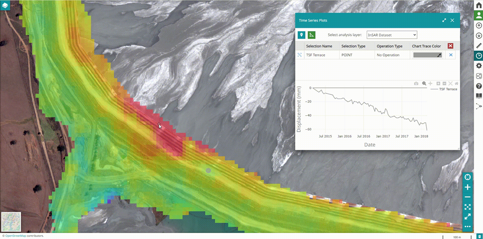
SatExplorer can incorporate the full range of VIRIDIEN Satellite mapping EO and EO-derived datasets including InSAR data. In this case, gaining ground displacement insights is a major requirement facing engineers and other end users interested in monitoring the performance of engineered assets. This is to identify areas that may require intervention before hazards emerge. VIRIDIEN’s SatExlorer and InSAR data are a perfect combination for asset stakeholders interested in risk management of structures such as Tailings Storage Facilities (TSFs) seen in the screenshot below. Here, the Engineer of Record (EOR) and the Responsible Tailings Facility Engineer (RTFE) can both access the same monitoring data, quickly identify the spatial distribution of ground displacement, and interrogate the time series of movement behind each pixel. Not only does this provide them with many magnitudes more monitoring measurements, but SatExplorer gives them the intuitive tools to make sense of this vast data set and identify, for example, where ground displacement is accelerating ahead of a potential slope failure.
SatExplorer is cloud-hosted for faster access and removing the headache of downloading data before you can gain value from it. Geotechnical professionals and other stakeholders only need their login and an internet connection to visualize, filter, analyze, and download their data.
For asset owners requiring portfolio monitoring, SatExplorer can provide you with customised dashboards highlighting specific data across all of your sites in one place. We are experienced in building and visualizing data sets so that we can highlight the information that matters most to you. And if what matters to you changes, we will change your data in SatExplorer with you so that the data you buy is always as actionable as we can make it.
SatExplorer supports direct integration with GIS applications. We are so committed to making sure our data delivers maximum impact, that our data can seamlessly be fed into your GIS applications to complement your existing workflows and reporting. Or indeed, if you are looking for a monitoring data integration solution that incorporates all your ground-based instrumentation and EO-derived data sets, VIRIDIEN’s all-encompassing geotechnical monitoring solution is iSiteCentral. You can read more about that and enquire on our website.
But if it’s Satellite Mapping data that you want to visualize and analyze quickly, precisely and at scale, look no further than SatExplorer from VIRIDIEN.
Our hope is to continue to work closely with our clients to make sure SatExplorer and our data sets are providing solutions to their objectives, requirements, and pain points. We will continue to seek out feedback and to further develop our products and services to maximize the successes that can be reached by us and our customers, together.