Satellite InSAR analysis of the Reykjanes Peninsula in the lead up to the eruption at Mount Fagradalsfjall on the 19th March 2021.
On March 19th, a volcanic eruption began at Geldingadalur, close to Fagradalsfjall on the Reykjanes Peninsula, Iceland. This is the first eruption in the Reykjanes peninsula in nearly 800 years. The lava is highly fluid with no explosive activity or ash produced during eruption.
This is not the first activity in the area in recent times, with periods of raised seismicity and inflation observed through 2020. Since mid-February 2021 the area had been affected by a prolific seismic swarm, and by early March the ongoing ground deformation was indicating intrusion of magma along a northeast-southwest trending zone.
Satellite InSAR is ideally suited to measure the spatial extent and magnitude of surface deformation associated with natural hazards such as earthquakes and injection of magma.
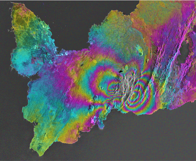
The figure below shows a wrapped interferogram, which compares radar signals for a descending line-of-sight (LOS) between March 7th and 19th, leading up to the eruption. An interferogram is a map of phase shifts that reveals a ‘snapshot’ of relative surface displacement over a short time period. The repeating stripes, known as fringes, can be considered ‘contours’ of deformation, with the tightly-packed fringes centered around Mount Fagradalsfjall showing strong displacement over the 12-day period before the eruption.
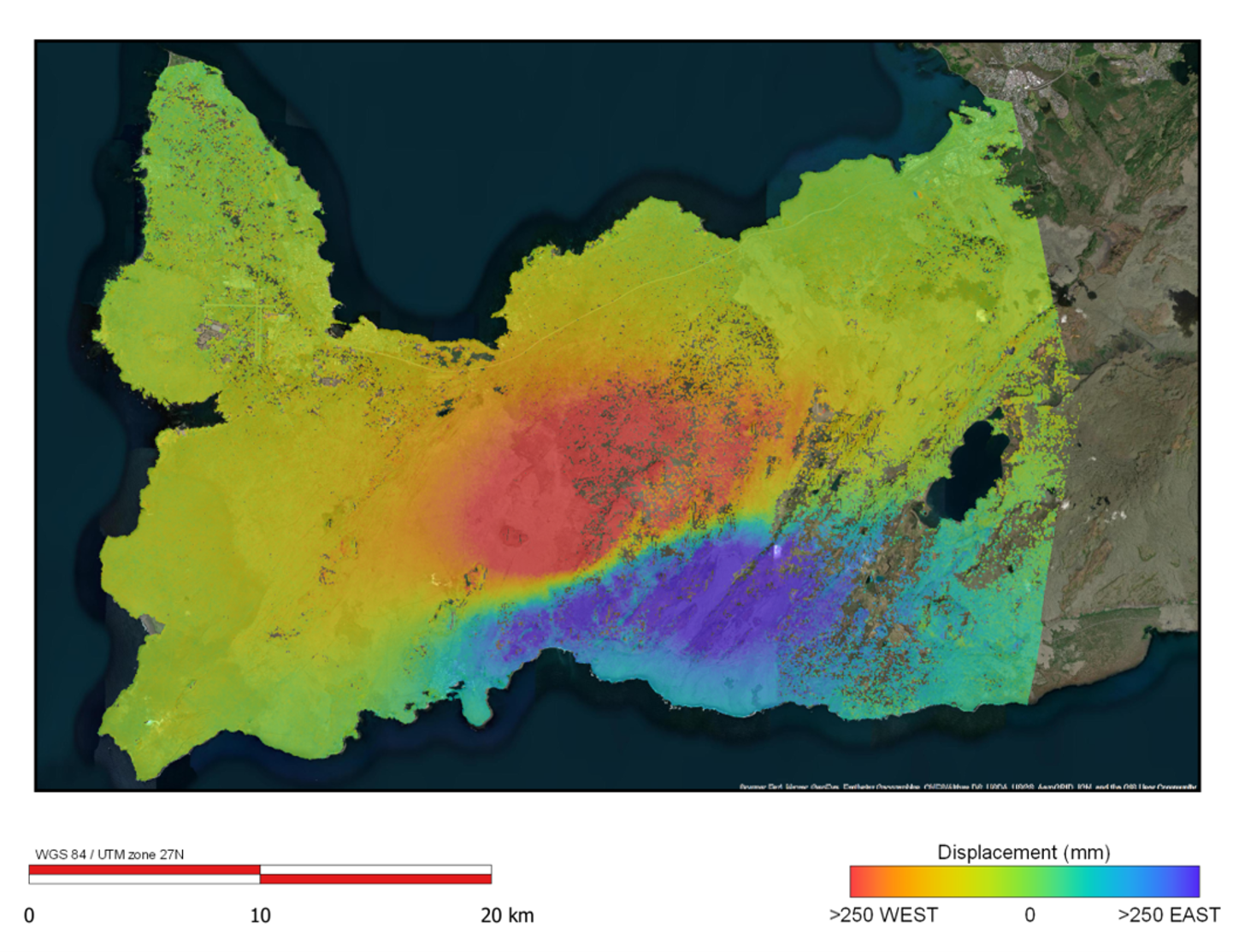
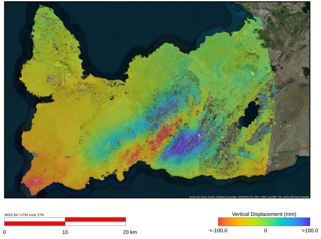
By combining multiple interferograms we can also study the cumulative deformation over a longer time period, and can split this into vertical and east-west components of displacement.
The following two figures show the cumulative east-west and vertical displacement from the last 12 months. This includes all movement from the ongoing volcano-tectonic reactivation of the Reykjanes peninsula starting in 2020.
The east-west component (below) is dominated by a clear displacement across a southwest-northeast trending fault zone. North of this zone there is significant movement to the east, whereas to the south relative movement is to the west, showing left-lateral strike slip displacement. This corresponds with the plate boundary in this region, and with the alignment of the seismicity over the period.
The vertical displacement (below) shows a more complex distribution of both uplift and subsidence, with an obvious influence from the intrusion of magma below the area. This intrusion caused uplift of the surface across the wider area, seen in blue.
The intruded magma formed a dyke, which eventually reached the surface resulting in the ongoing eruption. Directly above this dyke, the vertical displacement shows subsidence, in contrast to the uplift observed in surrounding areas. This is very typical of signals seen across dyke intrusions elsewhere, where the overall uplift and outward expansion stretches the overlying ground causing a subsiding trough known as a graben.
Since the dyke reached the surface on the March 19th, the ongoing eruption has produced a steady lava flow of 5-7 m3/s, building a small cone and progressively filling the Geldingadalur valley, and opening a second fissure further to the northeast. Chemical analysis has indicated the magma has risen relatively quickly from depth, and while predicting the future behaviour of eruptions is difficult, it could be possible for the eruption to continue for several months, if not years.
While we watch and wait to see how the eruption develops, a live feed of the volcano can be found here: Geldingadalur - Volcano (livefromiceland.is)
More background information on the eruption and updates on ongoing developments are provided by the Icelandic Met Office: https://en.vedur.is/about-imo/news/earthquake-swarm-in-reykjanes-peninsula
Header image: https://www.internetgeography.net/fagradalsfjall-eruption/
Email: satellite.info@cgg.com
Telephone: +44 (0)1732 865023
Website: www.cgg.com/satellite
LinkedIn: CGG Satellite Mapping
Twitter: @CGGsatellite