The Landsat-9 satellite was successfully launched from the Vandenberg Space Force Base in California on Monday September 27th 2021.
The first Landsat mission, launched in 1972 and originally called ERTS, was described in 1976 by the then director of the USGS, Dr. V. E. McKelvey, as follows: “The ERTS spacecraft represent the first step in merging space and remote-sensing technologies into a system for inventorying and managing the Earth’s resources.”
Landsat-9 represents the latest evolution of this very important, long-term satellite mission.
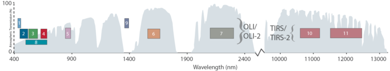
Landsat-9's Operational Land Imagery 2 (OLI-2) and Thermal Infrared Sensor 2 (TIRS-2) instruments will collected imagery across 11 spectral bands:
- Band 1 - Coastal/Aerosol - 433-453 nm - 30 m
- Band 2 - Blue - 450-515 nm - 30 m
- Band 3 - Green - 525-600 nm - 30 m
- Band 4 - Red - 630-680 nm - 30 m
- Band 5 - NIR - 845-885 nm - 30 m
- Band 6 - SWIR 1 - 1560-1660 nm - 30 m
- Band 7 - SWIR 2 - 2100-2300 nm - 30 m
- Band 8 - Panchromatic - 500-680 nm - 15 m
- Band 9 - Cirrus - 1360-1390 nm - 30 m
- Band 10 - Thermal - 10300-11300 nm - 100 m
- Band 11 - Thermal - 11500-12500 nm - 100 m
Importantly, Landsat-9 will collect 14-bit data i.e. 16,384 data values. This is in contrast to Landsat-7's 8-bit data, and Landsat-8's 12-bit data. This improves the ability to discriminate the signal over more data values.
Banner image credit: NASA/Bill Ingalls