78 years since being sunk on her maiden voyage and after several years of searching, the wreck site of the oil tanker SS Bloody Marsh was finally located last month by oceanographers from the National Oceanic Atmospheric and Administration (NOAA) with significant help from the SeaScope team at CGG Satellite Mapping.
The Bloody Marsh
Even before the entry of the United States into the Second World War (WW2), the need to mass produce cargo vessels was readily apparent. Shipping convoys from North America to the United Kingdom were taking heavy losses to U-Boat attack and as the war expanded to the Pacific following the Japanese attack on Pearl Harbor on 7th December 1941, the need for cargo vessels would only increase. American shipyards mobilised and began to mass produce ships at an extraordinary rate. Whilst today the Liberty and Victory ships remain well known, the similarly mass produced T2-SE-A1 class of oil tankers are relatively forgotten. Economically built with welded hulls and minimal onboard equipment, a typical ship could be built in as little as 70 days allowing for an astonishing 481 ships to be constructed by the war’s end.
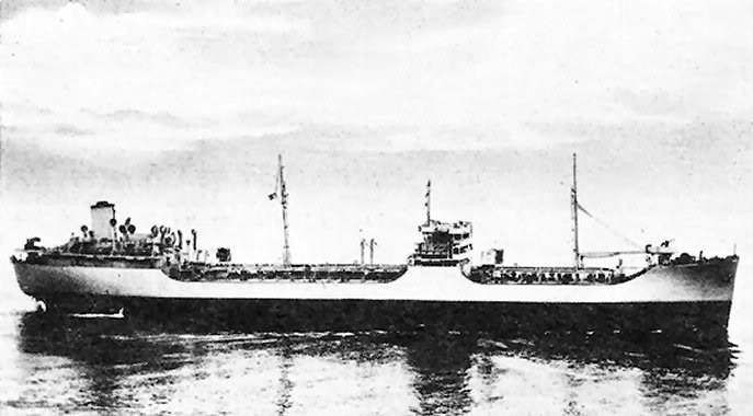
The SS Bloody Marsh was one such T2-SE-A1 oil tanker (below). Built in 1943, it was on its maiden voyage from Houston to New York when it was torpedoed twice by the German submarine U-66 on July 2nd that same year. The second torpedo struck the Bloody Marsh amidships, breaking the tanker in two and causing her to sink rapidly with the loss of three crew. Whilst her approximate final location was reported at the time, like many WW2 shipwrecks the accuracy of this location was poor and her true final resting place remained unknown.
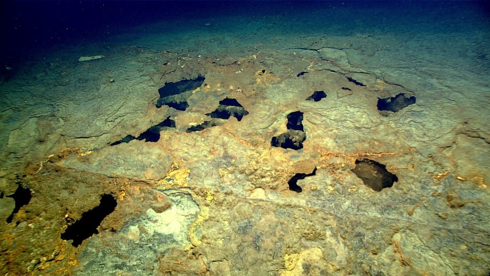
At the time of her sinking the SS Bloody Marsh had a cargo of approximately 106,500 barrels of oil onboard, much of which could remain inside the hull of the ship. As one of 87 shipwrecks on NOAA’s Potentially Polluting Wrecks (PPW) list it was important to first accurately locate the wreck and then inspect the site to determine the pollution risk posed by the vessel.
CGG Satellite Mapping joins the search
In 2019 the NOAA research vessel Okeanos Explorer undertook an expedition dive to a feature identified from bathymetry data as potentially being the shipwreck of the SS Bloody Marsh. Unfortunately the target ultimately proved to be a 500 ft (150 m) long rock outcrop, leaving the expedition empty handed. It was at this point CGG Satellite Mapping drew attention to potentially interesting sea surface oil slicks observed on satellite imagery of the region, which had been mapped as part of a wider US East Coast survey provided for their partner US government agency the Bureau of Ocean Energy Management (BOEM). The oil slicks (below) indicated a consistent seafloor oil source, 12 km south west of the historically documented position of the SS Bloody Marsh.
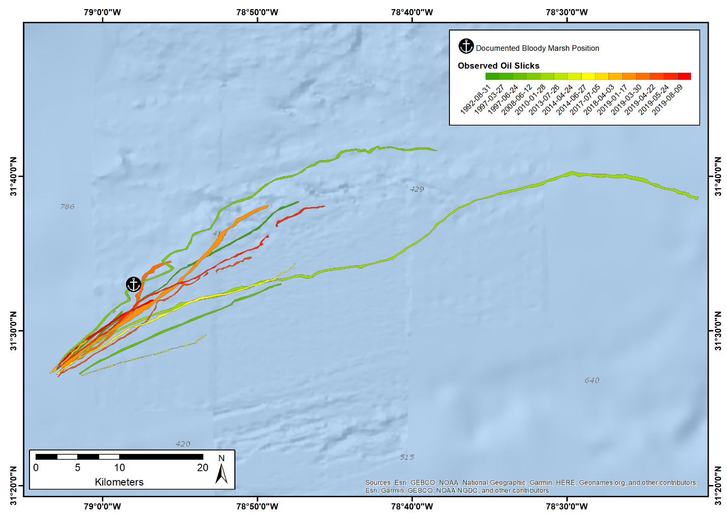
This information proved crucial in refining the search area for the wreck in the ‘Windows to the Deep’ survey cruise, also performed by Okeanos Explorer in the 2021 season. Within this new search area, a shipwreck-like target was found in the multibeam bathymetry data 4 km downstream of where the oil slicks originated at the surface. This separation of probable seafloor source origin to sea surface appearance is quite pronounced, indicative of the strong currents found off the coast of South Carolina due to the North Atlantic Gulf Stream.
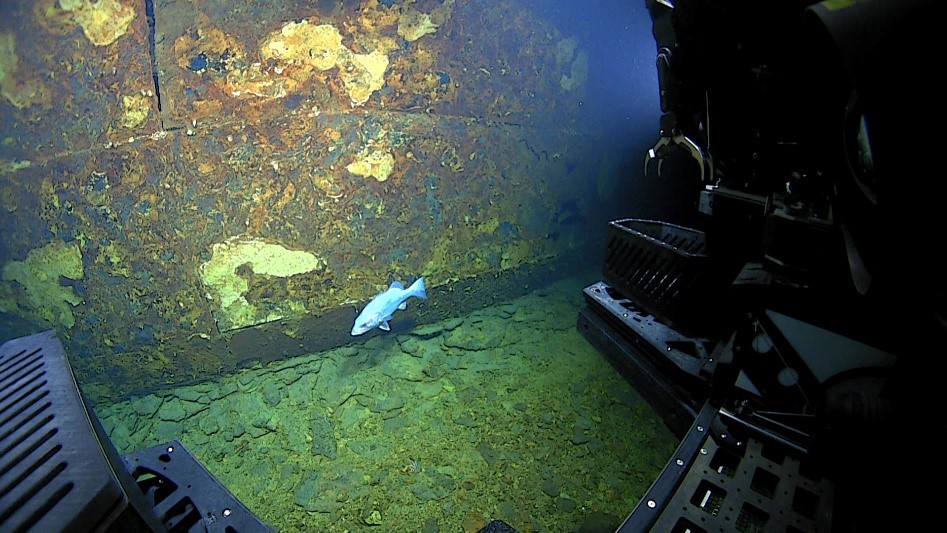
On 28th October 2021 the team conducted a dive at the bathymetry target, finding a shipwreck surrounded by a debris field of various corroded metal components. The welded hull segments and pattern of damage was consistent with that of the Bloody Marsh, with only the stern half of the ship found at the site (the lighter bow of the vessel is believed to have settled some distance away when the ship broke apart).
Overall the dive was a great success, bringing together years of effort and multiple data sources together from the various teams which contributed to the investigation.
For CGG Satellite Mapping this has been an exciting case study for our slick mapping work as it relates to shipwrecks and caps off a year of discoveries in the field by the team. The ability to detect and monitor events such as this is underpinned by recent advances in Earth observation (EO) technology that today sees more of the Earth’s surface being imaged at a higher frequency and resolution than ever before. Expert processing, interpretation and analysis is critical in converting this step-change in imaging capabilities into intelligence capable of providing early detection and qualification of sea surface slicks that have previously gone either unreported or undetected.
We continue to work closely with organisations looking to document and mitigate the oil spill pollution risks posed by the thousands of PPW sites originating from WW2 , and look forwards to sharing more of this exciting work through 2022.
Banner image: A remotely operated underwater vehicle (ROV) from the NOAA research vessel Okeanos Explorer explores the wreck of the SS Bloody Marsh. Image courtesy of NOAA Ocean Exploration, Windows to the Deep 2021.
Email: satellite.info@cgg.com
Telephone: +44 (0)1732 865023
Website: www.cgg.com/satellite
LinkedIn: CGG Satellite Mapping
Twitter: @CGGsatellite