This month marks the 75th anniversary of the Operation Crossroads nuclear testing at Bikini Atoll in the Republic of the Marshall Islands. The United States detonated two atomic weapons to understand the impact of nuclear attack on naval vessels, with the environmental consequences still being felt to this day.
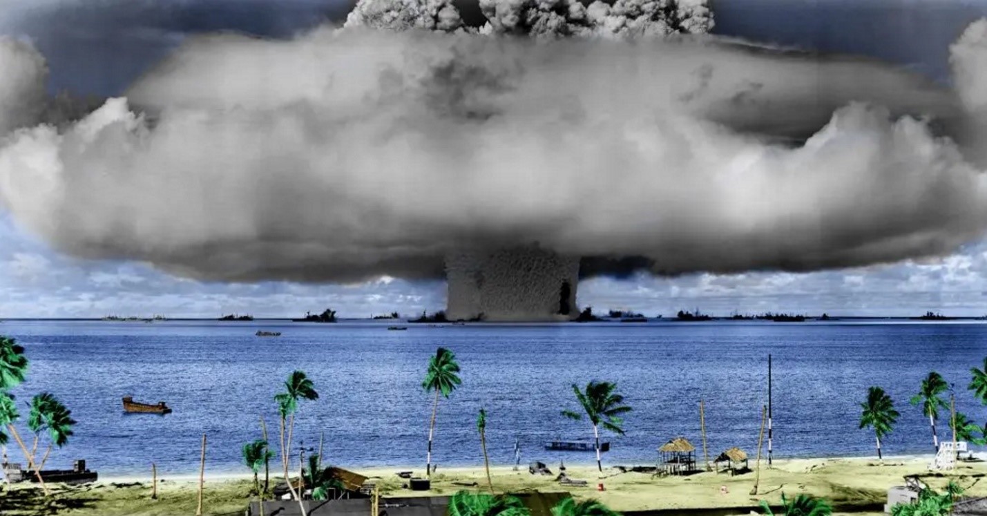
Test Baker, the second of the two tests, aimed to investigate the effects of an underwater explosion on a simulated enemy fleet at anchor. A 23-kiloton device was placed 27.5m under the surface in the NE of the lagoon and surrounded by 75 surplus vessels from WWII. These target ships were filled with varying levels of fuel oil and ammunition to simulate real world conditions. Of the 75 vessels at the test site, 12 were sunk, including two battleships, two submarines and the USS Saratoga a 36,000 ton aircraft carrier. The wrecks of these vessels remain at the bottom of the lagoon today, along with their loads of fuel oil and munitions.
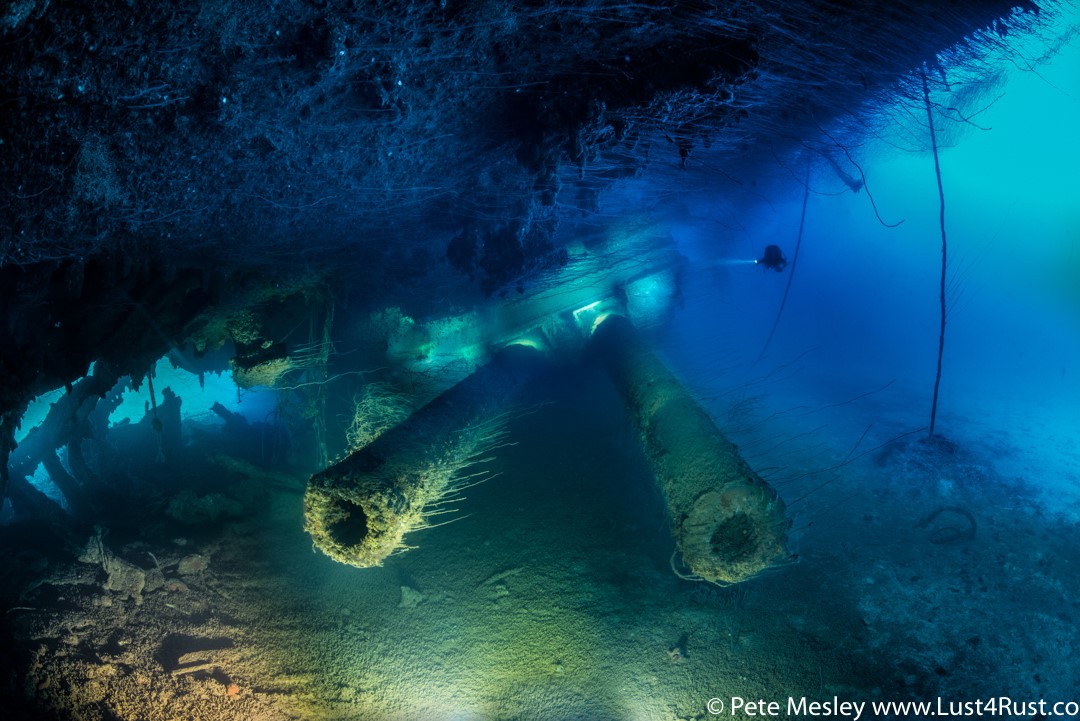
In 2010, the ‘Bikini Atoll Nuclear Test Site’ was designated as a UNESCO World Heritage Site for its outstanding universal value. The waters of the lagoon are recognised for their high biodiversity, providing some of the most significant reef habitat in the northern Pacific. In 2019, a multi-disciplinary team of scientists from the University of Delaware and SEARCH Inc revisited the wreck sites to survey the area and noted multiple oil leaks from the wrecks. However, the extent of the potential problem was still largely under explored.
Today, satellite remote sensing experts at CGG are collaborating with the Major Projects Foundation (MPF) to assess the environmental threat posed by these neglected vessels. Founded in 2018, the MPF is a marine research not-for-profit organisation working to protect Pacific ecosystems from polluting wrecks - throughout the region, there are more than 3,800 potentially polluting wrecks (PPW).
CGG has applied its SeaScope environmental monitoring solution to five years of satellite imagery revealing four vessels with leakage issues in the Bikini Atoll World Heritage Site.
Will Jeffery, CGG Satellite Mapping's Offshore Interpretation Manager, said “We have identified oil slicks stretching over 10 km in length to the edge of the lagoon, with the majority of the oil observed correlated to the location of the sunken Japanese battleship Nagato.” In addition to Synthetic Aperture Radar (SAR) data driven detection of oil on water, SeaScope’s expert analysis of multi-spectral optical imagery provides insight into oil-type and thickness on the sea surface. Will continued “On one date alone, a volume equivalent to approximately 4 barrels of oil was observed on the Bikini lagoon surface, which when extrapolated would imply there has been a significant volume of oil released from these ships into the surrounding marine ecosystem over the past 75 years. Utilising our team of remote sensing experts with deep experience in data selection and interpretation has allowed for the delivery of a robust high-quality product, focussing on historical results that can provide an extraordinarily valuable environmental baseline for future oil extraction and remediation activities.”
The survey and mitigation of oil spills from these sunken relics of the past is becoming critical. Wrecks deteriorate over time and the risk of a sudden and catastrophic release of the remaining oil increases dramatically. Such a spill would significantly impact the ecosystem of the Bikini Atoll World Heritage Site, further delaying the recovery of the ecosystem from the trauma of the atomic tests.
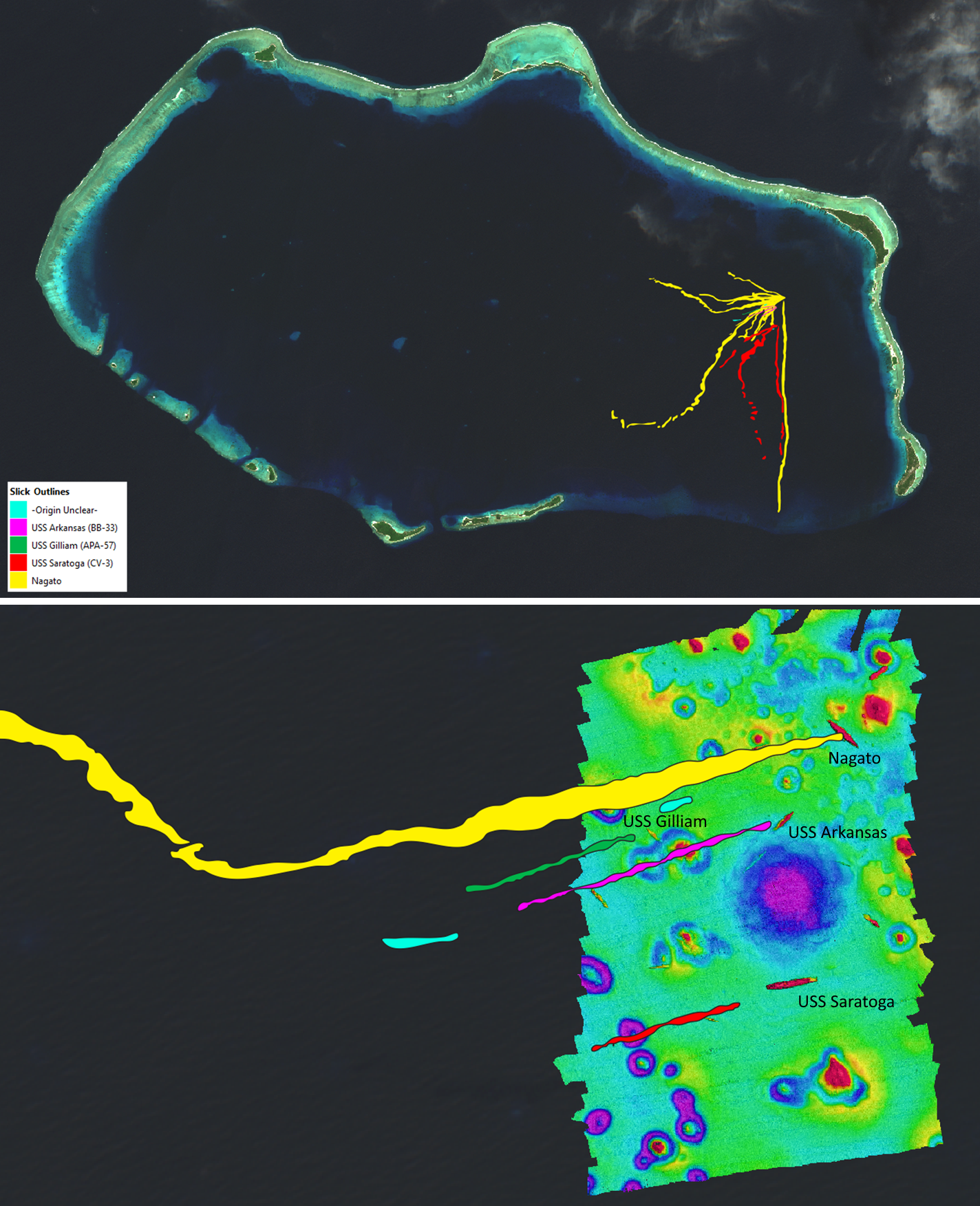
CGG’s SeaScope results have allowed the MPF to revaluate some of the more harmful wrecks, identify locations of previously lost wrecks, and draw attention to present day oil spills to relevant authorities. Satellite enabled monitoring of these sites has presented new insights, whilst also allowing continued investigation whilst in-person surveying work has been restricted by the global COVID-19 pandemic. The remoteness of the Bikini Atoll makes it a low priority for satellite imagery acquisitions, making the region data limited in terms of routine imagery. However, SeaScope’s advanced processing and expert analysis can source and interpret imagery from multiple sources and data types, producing critical environmental awareness and consistent monitoring.
Dr Matt Carter, MPF's Research Director, said “By collaborating with CGG we have been able to reveal that it is no longer a matter of if these wrecks are a threat, but instead to quantify this risk by assessing how much oil they are leaking and where it’s going. Significantly, the SeaScope results have enabled us to re-prioritise our database of PPW to focus on those shipwrecks that are actively leaking and therefore will require the most urgent attention once borders reopen.”
CGG and MPF continue to expand their partnership, working on this and other sites to heighten environmental awareness and deliver greater visibility of the interaction between potentially polluting wrecks and the local marine environment. SeaScope will continue to provide actionable intelligence to MPF in their mission to mitigate pollution risk posed by these neglected vessels to valuable Pacific ecosystems.
Major Projects Foundation:
- Web: https://majorprojects.org.au/
- Facebook: https://www.facebook.com/majorprojectsfoundation
- Twitter: https://twitter.com/MajorProjects
- Instagram: https://www.instagram.com/majorprojectsfoundation/